Trails in Spallumcheen
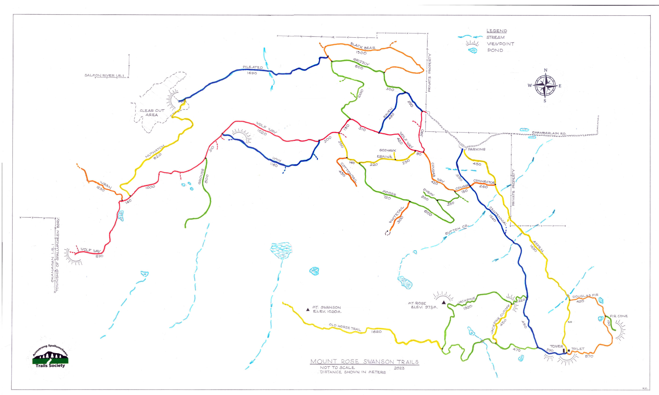
Mount Rose Swanson
Mt Rose Swanson trails at end of Chamberlaine Road
Most people don’t know that there is another network of old routes (old logging roads and skid trails) at the end of Chamberlaine Road, about a 400 m walk from the main parking. Please don’t park at the very end of the road as it is an emergency turnaround but rather park on the road shoulders below this area, or hike up from the main parking lot.
The ASTS is designing, and hopes to construct, two kiosks in this area – the main being at the parking lot. Panels will consist of a map of the routes and other interesting areas, and more general information.
- Please “pick up” after your dog
- Carry bear spray and know how to use it – you are in “bear country”
- Carry a whistle
- Do not expect always to have cell phone reception; it is very inconsistent and therefore unreliable in emergencies.
Directions to Mt Rose Swanson
To reach the hiking trails, coming from the South, turn into Armstrong off Highway 97A at the traffic lights. Turn right onto Smith Drive at the 3-way stop sign. Follow Smith Drive as it bears left turning into Pleasant Valley Road and then turn right at the (RCMP) 4-way stop.
Go over the railway tracks, turning left onto Wood Avenue, just beyond Shepherd’s Hardware. Follow this west for approximately 2 km then cross the railway tracks again, winding up the hill. The road turns sharp right and becomes Salmon River Road.
Follow through a left then a right-angled turn until you reach Hallam Road on your left, about 4 km from Armstrong. Follow Hallam Road for about 2 km through sharps turns and wiggles until you reach Chamberlaine Road (gravel) and make almost a U-turn to drive south.
Follow Chamberlaine Road for another 2 km (including another right-angled bend) and at a fork bear left; after about 0.5 km parking and the trailhead are on your left.
History behind the name
Rose was born in Kamloops to Catherine Schubert in 1862, a member of the ‘Overlanders’ who travelled from the Prairies by cart and rafted down the North Thompson River. Rose was named after the rose hips that they collected along the riverbank, to keep travelers from starving. She moved to Armstrong, married Henry Swanson, and lived on a large farm at the base of Mt Rose Swanson.
Warning and Safety Precautions
This is bear country; if you have bear spray, take it with you and know how to use it. There is no drinkable water anywhere on these trails so please pack your own. Wear above-the-ankle hiking boots. Hiking poles are recommended as are cameras and binoculars. Take food and snacks and be prepared to be out for at least 3 hours if hiking all the main trails. Carry a first aid kit (and know how to use it too). Let somebody know where you are and you expected arrival time home.
PLEASE NOTE: Motorized vehicles of any kind ARE NOT ALLOWED on the SW trails (Centennial, Aspen etc); they ARE allowed on the trails beginning at the end of Chamberlaine Road.
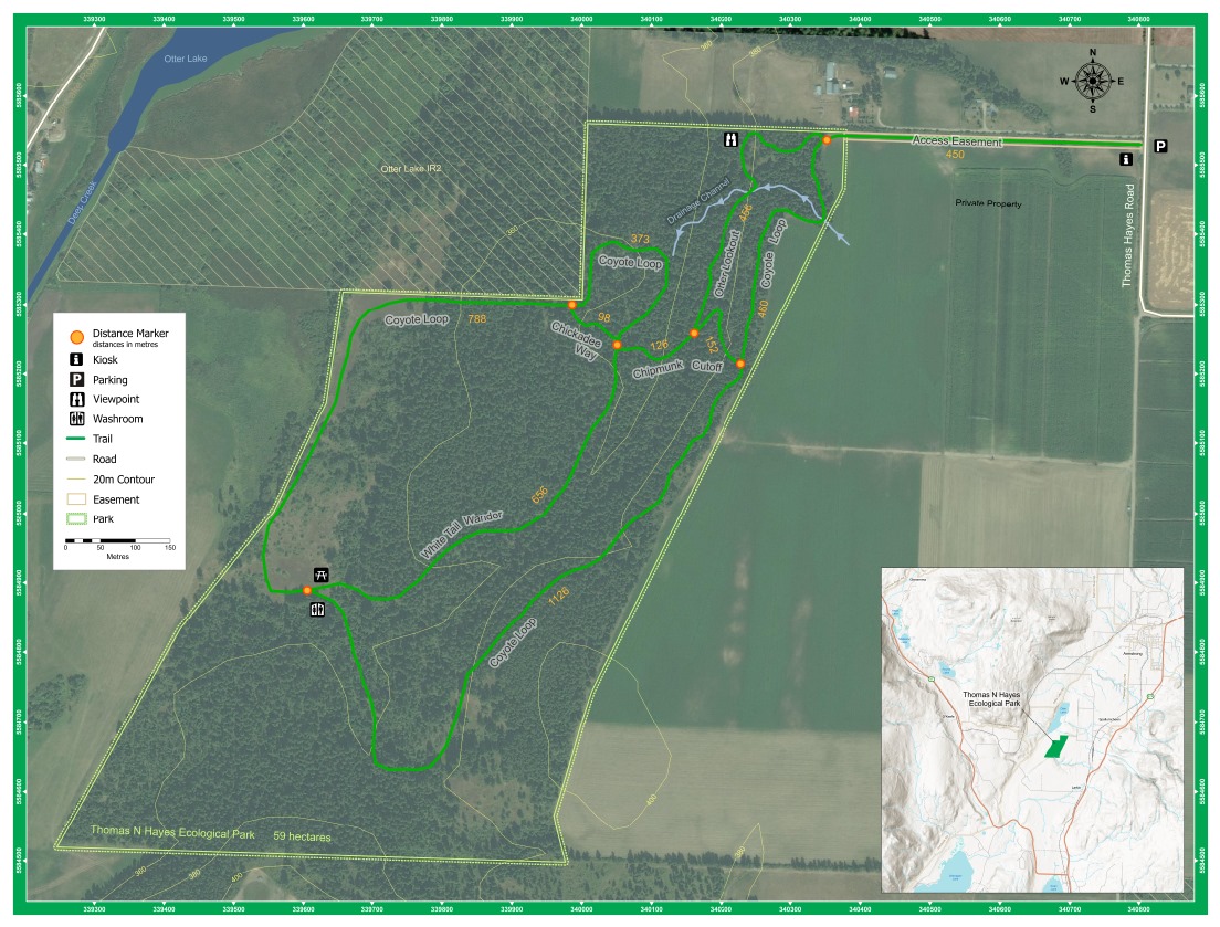
Thomas Hayes Ecological Park
Directions to Thomas Hayes Ecological Park – 1249 Thomas Hayes Road (Armstrong)
Coming from the NORTH – Starting at Armstrong’s IPE grounds in the city centre, you’ll be on Pleasant Valley Road; drive south for approximately 6 km to Crozier Road on which you turn right. After 850 m turn left at the T-junction, onto Otter Lake Cross Road and travel 800 m. Turn right onto Thomas Hayes Road and drive just over 1 km (including a 90º bendº and the parking lot for Thomas Hayes Ecological Park will be on your left.
Coming from the SOUTH – Vernon City Centre, at the intersection of 30th Avenue and 32nd Street (Highway 97A).
Head North on 32nd Street (Highway 97A) for 9.2 kms. Continue onto Highway 97A N for 4.7 kms. Take the exit toward Otter Lake Cross Road for 300 m to the 1st roundabout; take the 4th exit and travel 140 m. At the 2nd roundabout take the 1st exit onto Otter Lake Cross Rd and travel 2.1 kms. Turn left onto Thomas Hayes Road and drive just over 1 km (including a 90º bendº and the parking lot for Thomas Hayes Ecological Park will be on your left.
Or simply use Google Maps and enter 1249 Thomas Hayes Road, Armstrong, BC
Trails in Armstrong
These throughways traverse sensitive ecosystems and as such, must be protected by all. You can help by picking up any garbage you see, and by watching wildlife from a respectful distance so that the animals will continue to feel safe and respectful of their habitat.
Heritage Tours
The City has many heritage buildings which have been designated with a green and gold plaque titled “Looking Back” which describes the history of the building. These buildings can be found in the downtown core along Okanagan Street, and both sides of Pleasant Valley Boulevard.
More detailed heritage walking and driving tour pamphlets can be found in the Armstrong Spallumcheen Museum and Art Gallery, or at the Armstrong Spallumcheen Chamber of Commerce; these two facilities are adjacent buildings on Bridge Street off Pleasant Valley Road.
Below is a list of non-paved trails in Armstrong.
Chip Trail
Location: behind the Pleasant Valley Senior Secondary School on Pleasant Valley Road. Walk along the south fence of school field to get to trails. No dogs allowed.
Length: 1.3 km (including walk along fence and the outer perimeter loop)
Parking: Park by the fence, south lot of the school
Seating: None
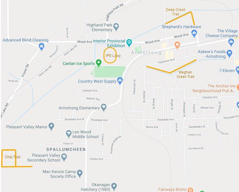
Meighan Creek Trail
Location: off Okanagan Street
Length: 540 m
Parking: Patterson Avenue Street Parking
Seating: Several benches
IPE Loop
Location: IPE Grounds
Length: One loop is 500 meters long
Parking: Abundant parking
Seating: None
Deep Creek Trail
Location: North end of Mill Street
Length: 465 m
Parking: Street Parking on Mill Street and Kirton Avenue
Seating: None
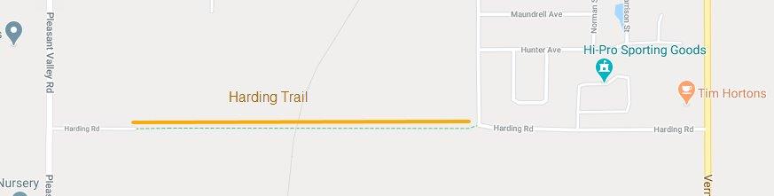
Harding Trail
Location: Off Okanagan Street and Pleasant Valley Road (it is a connector trail)
Length: 1 km
Parking: A couple of parking spots on Okanagan Street
Seating: Bench at start of trail
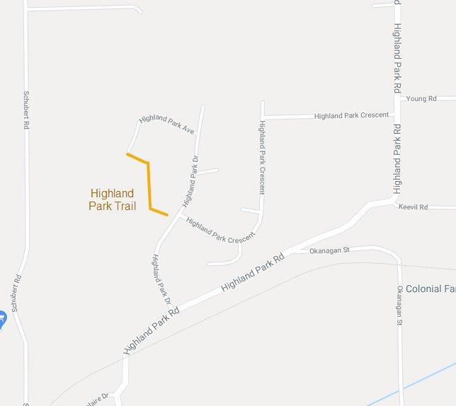
Highland Park Trail
Location: Highland Park Area
Length: 215 m
Parking: Street Parking
Seating:
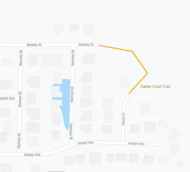
Game Court Trail
Location: Game Court and Bradley Drive Connector
Length: 170 m
Parking: Street Parking
Seating: